Planned Route and Estimated Statistics
(M) = Munro
(C) = Corbett
(G) = Graham
(Ma = Marilyn)
(O = Other Hill)
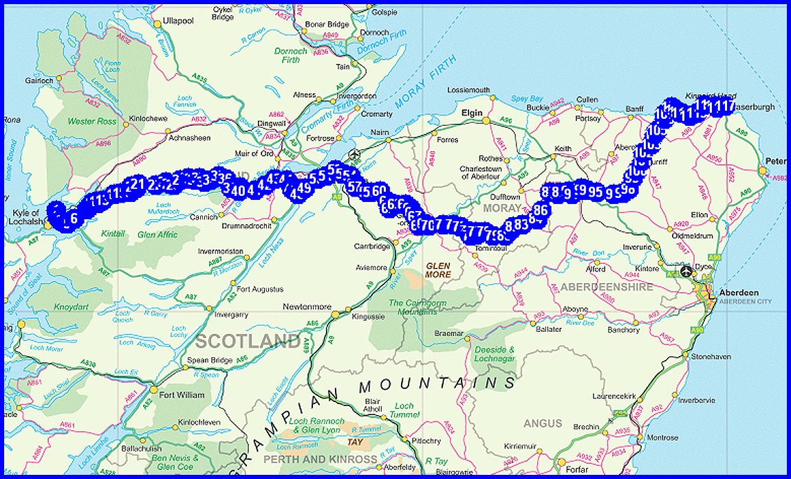
Day 1 - Friday 10 May
1 PLOCKTON (Plockton Hotel)
2 Loch Achaidh na h-Inich
4 Auchtertyre Hill (Ma)
5 Maol Mor (O)
9 Loch nan Gillean
Plan
22 km
1130 metres ascent
9.2 hours
(1 Marilyn)
(1 Other)
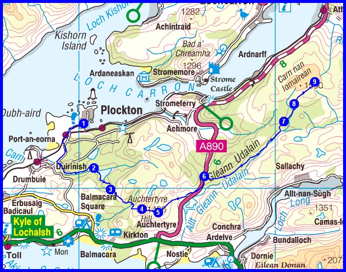
Day 2 - Saturday 11 May
1 Loch nan Gillean
7 Bendronaig Lodge
8 Loch Calavie
10 Bidean a’ Choire Sheasgaich (M)
11 Lurg Mor (M)
12 Camp to NE of col
Plan
24 km
1440 metres ascent
10.75 hours
(2 Munros)
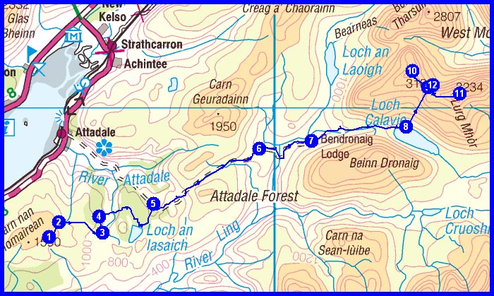
Day 3 - Sunday 12 May
1 Camp to NE of col
5 Path junction by Loch Monar
8 Carn Eiteige (O)
8-9 Sgurr na Fearstaig (O)
9 Sgurr Fhuar-thuill (M)
10 Creag Ghorm a’ Bhealaich (O)
11 High lochan at NH 251 436
Plan
24 km
1340 metres ascent
10.7 hours
(1 Munro)
(3 Others)
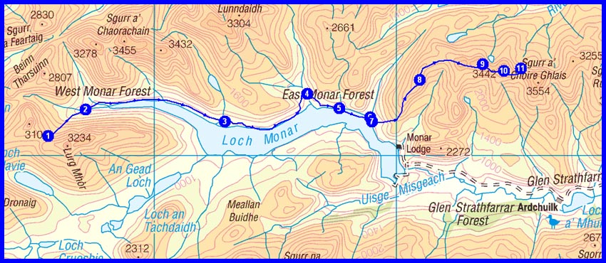
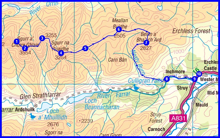
Day 4 - Monday 13 May
1 High lochan at NH 251 436
2
Sgurr a’ Choire Ghlais (M)
3 Carn nan Gobhar (M)
4 Sgurr na Ruaidhe (M)
5 Aonach na Reise
6
Meallan Buidhe (O)
7 Beinn a’ Bha’ ach Ard (C)
8 Dunmaglass
10 Cnoc Hotel, Struy
Plan
25 km
1150 metres ascent
11.0 hours
(3 Munros)
(1 Corbett)
(1 Other)
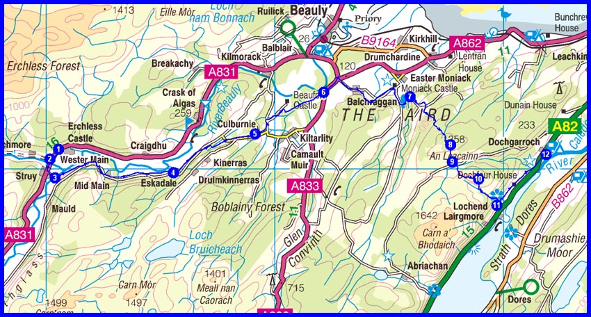
Day 5 - Tuesday 14 May
1 Cnoc Hotel, Struy
4 Eskadale
5
Culburnie
7 By Moniack Burn
8 An Leacainn (O)
10
Cnoc na Gaoithe (O)
12 Dochgarroch Campsite
Plan
33 km
910 metres ascent
12.1 hours
(2 Other)
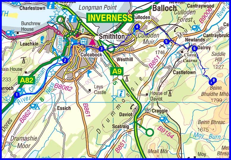
Day 6 - Wednesday 15 May
1 Dochgarroch Campsite
4 Culloden Village
5 Culloden Battlefield
6 Dalroy
7 Wild camp in vicinity of
NH 785 418
Plan
27 km
580 metres ascent
9.0 hours
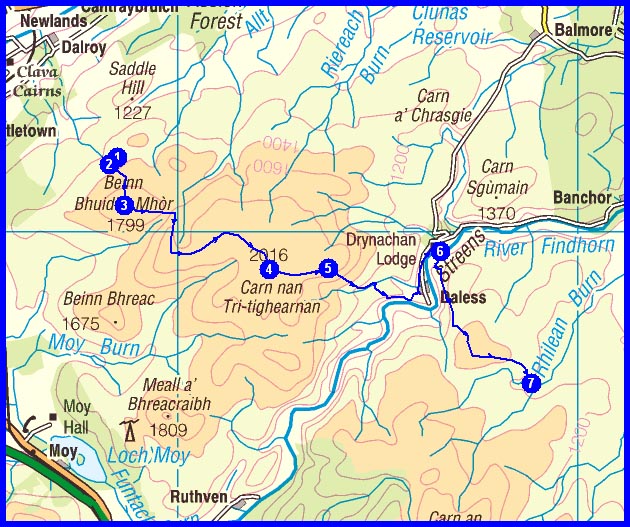
Day 7 - Thursday 16 May
1 Wild camp in vicinity of
NH 785 418
3 Beinn Bhuidhe Mhòr (O)
3-4 Carn Dubh Mòr (O)
4 Carn nan Tri-tighearnan (G)
5
Carn an Uillt Bhric
6 Bridge at Drynachan
6-7 Carn na Sguabaich (O)
7 Wild camp in vicinity of hut at
NH 888 362
Plan
18 km
650 metres ascent
7.1 hours
(1 Graham)
(3 Others)
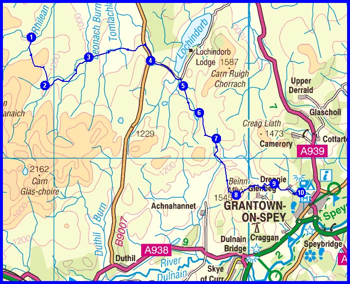
Day 8 - Friday 17 May
1 Wild camp in vicinity of hut at
NH 888 362
3 Track by Knockdu
4 B9007 junction
5
Drumroy
6 Loch an t-Sidhein
8 Beinn Mhòr (Ma)
9 West Gorton
10 Grantown-on-Spey (Campsite)
Plan
25 km
600 metres ascent
9.0 hours
(1 Marilyn)
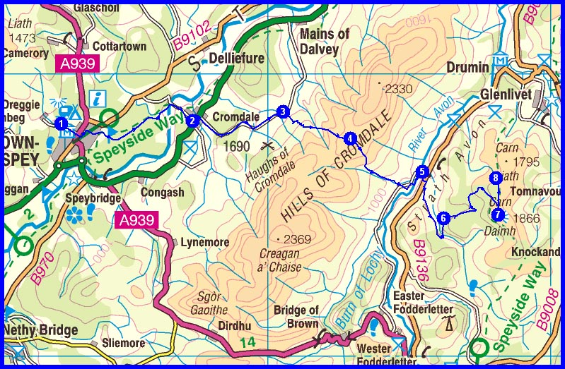
Day 9 - Saturday 18 May
1 Grantown-on-Spey
2 A95 at Cromdale
3 By Wester Rynaballoch
4 Cromdale watershed
5 By Ballenlish
7
Carn Daimh (Ma)
8
Wild camp in vicinity of
NJ 180 263
Plan
26 km
900 metres ascent
9.75 hours
(1 Marilyn)
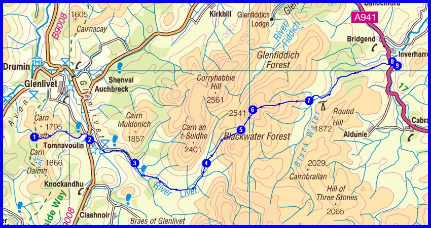
Day 10 - Sunday 19 May
1 Wild camp in vicinity of
NJ 180 263
2 Tomnavoulin
4 Suie
6
Cook's Cairn (G)
7 Path by Blackwater Lodge
8 The Grouse Inn at Ardwell
9 Wild camp by Ardwell
Plan
27 km
720 metres ascent
9.8 hours
(1 Graham)
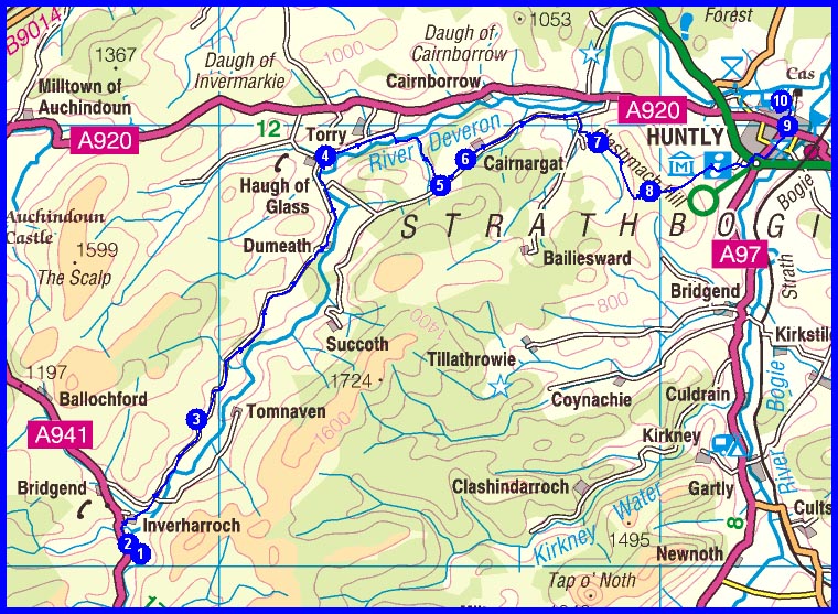
Day 11 - Monday 20 May
1 Wild camp by Ardwell
3 Succoth
4 Haugh of Glass
5 By Malach
6 Cairnargat
7 Wellheads
8 Clashmach Hill (O)
9 Huntly
10 Huntly Campsite
Plan
28 km
560 metres ascent
9.75 hours
(1 Other)
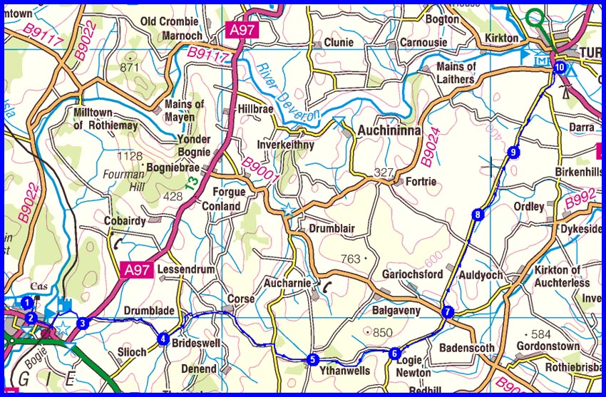
Day 12 - Tuesday 21 May
1 Huntly Campsite
2 Huntly
3 A97
4 Brideswell
5 Ythanwells
6 Logie Newton
7 Thorneybank
8 Mid Pitglassie
9 Braefoot
10 Turriff - Campsite
Plan
32 km
440 metres ascent
10.4 hours
Day 13 - Wednesday 22 May
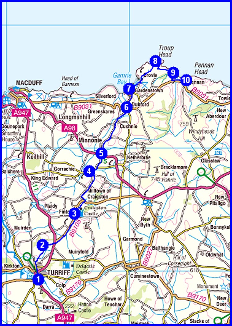
1 Turriff - Campsite
2 Meikle Hilton
3 Fintry
4 Mains of Fisherie
5 A98 road
6 Dubford
7 Gardenstown
8 Troup Head
9 By Cullykhan bay
10 Pennan Inn
Plan
30 km
710 metres ascent
10.6 hours
Day 14 - Thursday 23 May
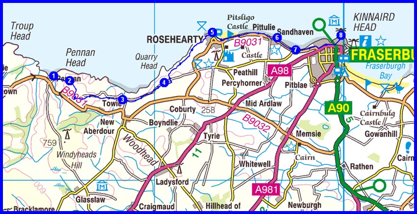
1 Pennan Inn
2 Pennan Farm
3 Mill Farm
4 By Egypt
5 Rosehearty
6 Sandhaven
8 Frazerburgh
Lift back to Montrose with Sue, plus possibly Lilo Pete and West Indian William
Plan
20 km
350 metres ascent
6.75 hours
2013 Plan
Total Distance 361 km (225 miles)
Total Ascent 11480 metres
Time 135 hours including stops
6 Munros
1 Corbett
2 Grahams
3 Marilyns not included above
11 'Other' hills
NB Timings are based on 3.5 kph, plus an hour for each 500 metres of ascent and another hour for each 1000 metres of descent. This is realistic in the mountains but very conservative for the easier sections of the walk.
| Actual | 2012 (S+M) |
2011 (M+Mike) |
2010 (M solo) |
2009 (S+M) |
2008 (S+M) |
2007 (M solo) |
| Total Distance in km (miles) | 426 (266) |
350 (219) |
347 (217) |
333 (208) |
323 (202) |
343 (214) |
| Ascent in metres | 10,100 |
12,130 |
15,500 |
12,400 |
12,544 |
12,942 |
| Hours taken including stops | 114 |
115 |
136 |
118 |
112 |
113 |
| Munros | 2 |
5 |
2 |
13 |
16 |
2 |
| Corbetts | 1 |
3 |
16 |
1 |
3 |
8 |
| Grahams | 0 |
2 |
4 |
3 |
1 |
2 |
| Marilyns not included above | 4 |
3 |
1 |
0 |
0 |
1 |
| Actual | 2013 |
|||||
| Total Distance in km (miles) | 374 (234) |
|||||
| Ascent in metres | 10,580 |
|||||
| Hours taken including stops | 114 |
|||||
| Munros | 2 |
|||||
| Corbetts | 0 |
|||||
| Grahams | 3 |
|||||
| Marilyns not included above | 4 |