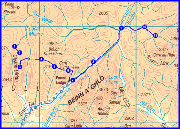
Planned Route and Estimated Statistics
(M) = Munro
(C) = Corbett
(G) = Graham
Day 1 - Friday 8 May
1 Inverie – via the boat from Mallaig
2 Torcuileainn
3 Point at 275 metres at NG 847 016
4 Mam Barrisdale
5 Luinne Bheinn (M)
6 Wild camp at head of Allt a Choire Odhair at NG 871 001 (approx 680 metres)
Plan
13 km
1100 metres ascent
6.5 hours
(1 Munro)
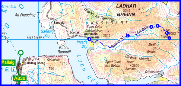
Actual
13.3 km
1107 metres ascent
5.9 hours incl 1 hour stops
(1 Munro)
Links to blog:
Index
Nearly ready
1st Prologue
2nd Prologue
Day 1
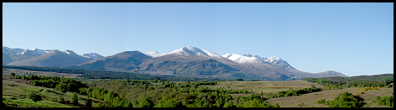
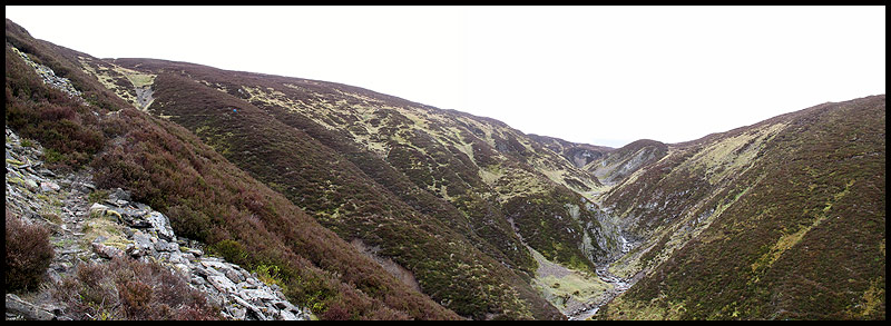
A smooth journey to Mallaig was followed by an easy walk in showery weather up a good path to Mam Barrisdale. It was windy there. The ascent of Luinne Bheinn was straightforward, but the descent to our camping spot needed care. We camped on the col, rather than descend a little way to a sheltered lochan, and enjoyed a good night's sleep.
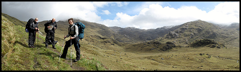
Bill Childs, Brian Aspinall and Sue on the good path to Mam Barrisdale, with Luinne Bheinn in cloud above Sue's head
Day 2 - Saturday 9 May
1 Wild camp
2 Summit at 839 metres
3 Bealach
4 Summit at 942 metres
5 Meall Buidhe (M)
4 Summit at 942 metres
6 Mam Meadail
7 Carnoch
8 Sourlies
9 Sgurr na Ciche (M)
10 Feadan na Ciche col
11 Wild camp at high lochan at NM 906 963 (approx 900 metres)
Plan
14 km
1700 metres ascent
8.0 hours
(2 Munros)
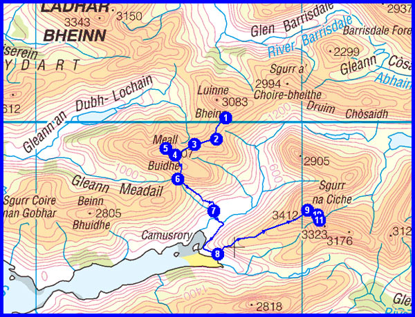
Actual
13.6 km
500 metres ascent
7.4 hours incl 1.7 hours stops
Links to blog:
Index
Day 2
We adopted our FWA (Foul Weather Alternative) today for the first time ever, due to cloud and slippery snow on the Knoydart ridges that we had planned to traverse, together with a snowline of 550 metres and a planned camp at 900 metres.
Our descent to the River Carnach needed care, and the rest of our low level day with occasional showers was slowed by boggy paths, river crossings, and a lack of urgency due to the shortened route.
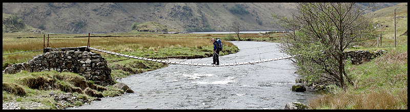
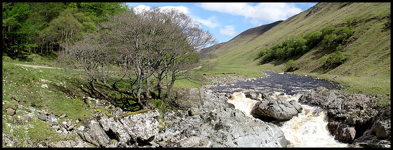
Martin crosses the welcome bridge, constructed in 1980, at Carnoch
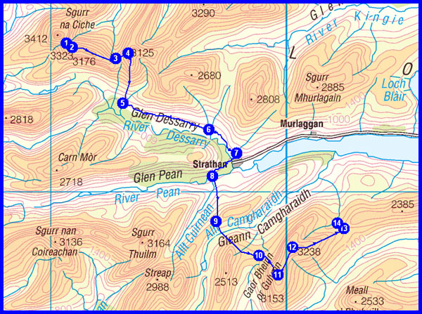
Day 3 - Sunday 10 May
1 Wild camp
2 Garbh Chioch Mhor (M)
3 Col at 736 metres
4 Sgurr nan Coireachan (M)
5 Path by Allt Coire nan Uth
6 Glendessary
7 Strathan
8 Bridge
9 Col at 436 metres
10 By Gualann nan Osna
11 Gulvain south summit
12
Gulvain north summit (M)
13
Col at 540 metres
14 Wild camp by Allt a' Choire Screamhaich at NN 021 886 (approx 480 metres)
Plan
22 km
1800 metres ascent
10.7 hours
(3 Munros)
Actual
19.8 km
1495 metres ascent
10.6 hours incl 1.9 hours stops
(1 Munro)
Links to blog:
Index
Day 3
This was a tough day in good weather. First continuing along Knoydart's boggy paths, mainly now in Glendessarry. Then over an intermediate ridge with fine views, to a final steep ascent of Gulvain and a fabulous wild camp on a balcony at 620 metres, with fine views towards Ben Nevis.

Sue enjoys her lunch near Leac na Carnaich, with a fine view towards Streap and Sgurr Thuilm
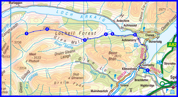
Day 4 - Monday 11 May
1 Wild camp
2 Mullach Coire nan Geur-oirean (G)
3 LRT in Glenmallie
4 Bridge
5 Track
6 Track junction
7 Torness - Gairlochy Holiday Park - camp site at NN 188 836 (60 metres)
Plan
23 km
530 metres ascent
8.6 hours
(1 Graham)
Actual
23.2 km
481 metres ascent
7.7 hours incl 1.7 hours stops
(1 Graham)
Links to blog:
Index
Day 4
A lovely stroll over a fine, broad ridge, with the waters of Loch Arkaig mirror still below us. A long lunch beside the loch was followed by an easy stroll in shorts and t-shirts to Gairlochy, and a pleasant afternoon with Carole Sinclair.
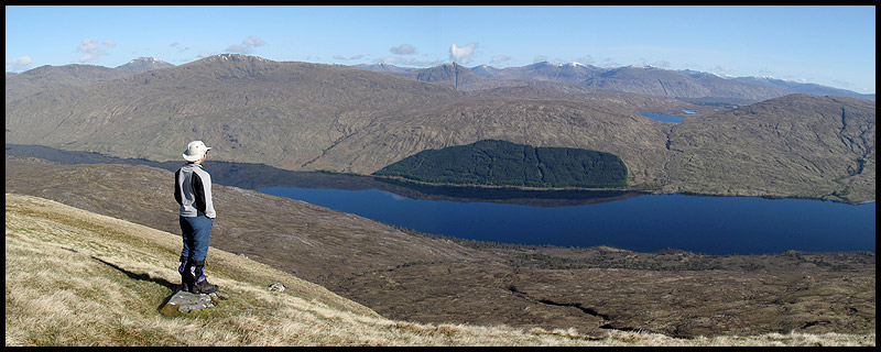
Sue admires the reflections in Loch Arkaig
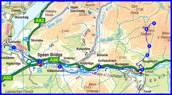
Day 5 - Tuesday 12 May
1 Gairlochy Holiday Park
2 Spean Bridge
3 Bridge
4 Achluachrach
5 Burnside Cottage
6 Path junction
7 Turn to ascend
8 Beinn Teallach (M)
9
Wild camp near Cairn at Tom Mor - NN 371 867 (approx 600 metres)
Plan
29 km
1200 metres ascent
12.0 hours
(1 Munro)
Actual
29.6 km
1166 metres ascent
10.4 hours incl 2.3 hours stops
(1 Munro)
Links to blog:
Index
Day 5
Spean Bridge's Little Chef provided a truly 'Olympic Breakfast' to help us speed off, initially with Carole Sinclair, on good paths to the south of the River Spean. A short road section then led to pleasant woodland where we enjoyed lunch before ambling up the gentle slopes of Beinn Teallach. A heathery camping spot in the lee of a freshening easterly wind had a very 'wilderness' feel to it.
Aonach Mor and Ben Nevis from our path to Spean Bridge, below the Commando Memorial
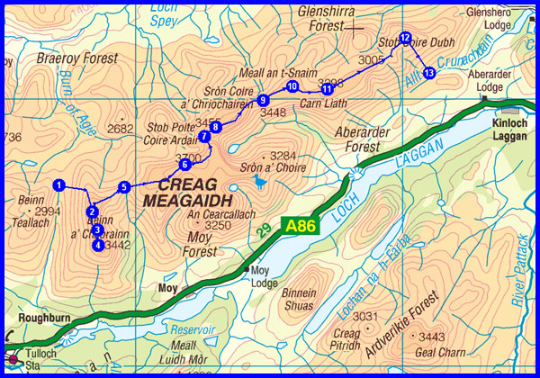
Day 6 - Wednesday 13 May
1 Wild camp
2 North top of Beinn a' Chaorainn
3 Beinn a' Chaorainn (M)
4 South top of Beinn a' Chaorainn
3 Beinn a' Chaorainn
2 North top of Beinn a' Chaorainn
5 Bealach a' Bharnish
6 Creag Meagaidh (M)
7 The Window
8
Stob Poite Coire Ardair (M)
9 Summit at 991 metres
10 Meall an t-Snain
11 Carn Liath (M)
12 Summit at 903 metres
13 Wild camp at stream junction by Allt Crunachdain - NN 510 909 (approx 450 metres)
Plan
21 km
1300 metres ascent
9.6 hours
(4 Munros)
Actual
21.9 km
1289 metres ascent
8.6 hours incl 1.3 hours stops
(4 Munros)
Links to blog:
Index
Day 6
A beautiful day with clear skies and crystalline views. But it was tough, due to a cold easterly wind from which there was very little respite.
A really fine mountain excursion, with another remote wild camp.
Sue admires the view, with Ben Nevis to the right, from the north summit of Beinn a' Chaorainn
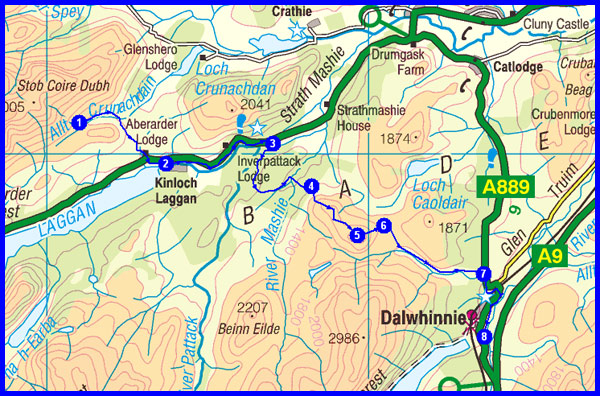
Day 7 - Thursday 14 May
1 Wild camp
2 Kinloch Laggan
3 Feagour
4 Forest edge
5 Meall nan Eagan (G)
6
Path by ridge
7
A889 road
8 Dalwhinnie Inn (with a proper bed at 360 metres!)
Plan
21 km
600 metres ascent
8.3 hours
(1 Graham)
Actual
22.2 km
748 metres ascent
7.5 hours incl 1.5 hours stops
(1 Graham)
Links to blog:
Index
Day 7
Loch Laggan was reached easily and afforded excellent reflective views. The path to Dalwhinnie was hard work and hard to navigate, with the very rough minor summit of Meall nan Eagan, in a still brisk easterly, proving quite demanding.
It was good to join Denis Pidgeon and others at the Dalwhinnie Inn for a jolly afternoon and evening.
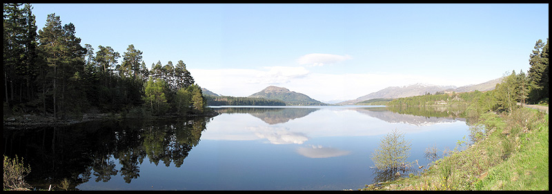
Loch Laggan - mirror smooth in the morning sunshine
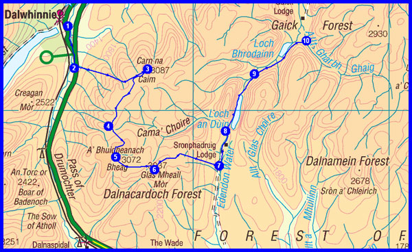
Day 8 - Friday 15 May
1 Dalwhinnie Inn
2 Leave the A9
3 Carn na Caim (M)
4 A' Bhuidheanach
5 A' Bhuidheanach Bheag (M)
6 Glas Mheall Mòr
7 Edendon Water
8 Path junction
9 Another path junction
10 Wild camp by Lochan a' Ghaorra - NN 758 835 (approx 450 metres)
Plan
27 km
1000 metres ascent
11.1 hours
(2 Munros)
Actual
27.8 km
1040 metres ascent
8.5 hours incl 0.5 hour stops
(2 Munros)
Links to blog:
Index
Day 8
On a cloudy day, with the persistent cool easterly on top, we spent several hours high up in the treeless Dalnacardoch Forest. Good paths led us easily over the two planned Munro summits, from which we descended roughly down to Edendon Water, and a path north past a derelict lodge to Gaick. Just as we were looking for a camping spot before the rain started, we met four jolly Challengers - Heather, John, Peter and Barbara. They continued into the face of the easterly and its moist accompaniment whilst we stopped in a sheltered spot before we got wet.
Setting off from Dalwhinnie, in fair weather, with Carn na Caim's summit to the left
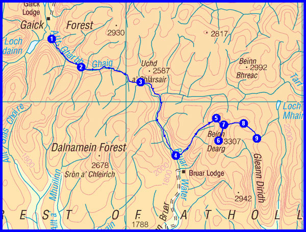
Day 9 - Saturday 16 May
1 Wild camp by Lochan a' Ghaorra
2 Path junction
3 Feith Ghorm Ailleag
4 Path junction
5 Beinn Gharbh
6 Beinn Dearg (M)
7 Northern summit of Beinn Dearg
8 Elrig 'ic an Toisich
9
Wild camp near col - NN 874 779
(approx 740 metres)
Plan
20 km
1000 metres ascent
8.5 hours
(1 Munro)
Actual
19.5 km
970 metres ascent
8.3 hours incl 1.2 hours stops
(1 Munro)
Links to blog:
Index
Day 9
A very rough crossing over a high watershed to Glen Bruar, where we had a fruitful encounter with Peter and Barbara. Whilst they continued to Blair Atholl, we headed up Beinn Dearg in damp weather (the camera was stashed away nearly all day), but amazingly we got a view from the top. We descended to another high watershed - 720 metres - for yet another excellent wilderness camp.
Mountain scenery at the head of Glen Bruar
Day 10 - Sunday 17 May
1 Wild camp at 740 metres
2 Carn a' Chiaraidh
3 Beinn Mheadhonach (C)
4 Aonach na Cloiche Moire
5 Carn a' Chlamain (M)
6 South of Allt na Maraig
7
Path junction by Forest Lodge
8 Past bridge
9 Past Falls of Tarf
10 Fealar Lodge
11 Wild camp at Allt a' Ghlinne Bhig
- NO 020 790 (approx 600 metres)
Plan
23 km
1100 metres ascent
10.0 hours
(1 Munro, 1 Corbett)
Actual
23.0 km
1093 metres ascent
9.6 hours incl 1.3 hours stops
(1 Munro, 1 Corbett)
Links to blog:
Index
Day 10
After waking in cloud, we enjoyed clearing weather as we ascended today's Corbett and Munro. A beautiful winding path led down into Glen Tilt, and a fine sheltered lunch spot. Then we enjoyed the beautiful glen in wonderful weather, up to the Falls of Tarf. Another lovely path led over to the pink buildings of Fealar Lodge, a remote working farm. From there we headed over high moorland to our final wild camp of the trip, a lovely flat grassy area reached via a river crossing. We were alone at all of our 8 wild campsites of the trip, and saw nobody else whilst at any of these remote spots.
Glen Tilt, from our lunch spot
Day 11 - Monday 18 May
1 Wild camp
2 Col at 780 metres
3 Carn an Righ (M)
2 Col at 780 metres
4 End of ridge
5 Glas Tulaichean (M)
6 Glenlochsie Lodge
7 Dalmunzie House
8 Spittal of Glenshee Hotel (340 metres - start of 'the TGOC for softies')
Plan
18 km
840 metres ascent
7.7 hours
(2 Munros)
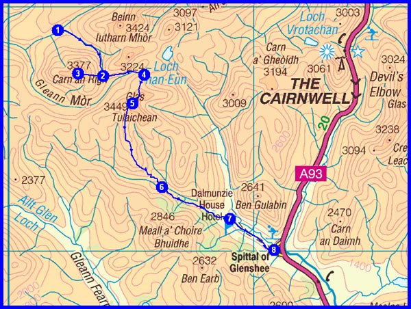
Actual
20.6 km
853 metres ascent
7.0 hours incl 1.1 hours stops
(2 Munros)
Links to blog:
Index
Day 11
For only the second day of the trip, the camera was stashed for most of the day due to persistent rain. But the cloud base remained high and we got a view from our first Munro, Carn an Righ. The rain was cold. We overshot the ridge up Glas Tulaichean by over 500 metres
due to low cloud and a failure to concentrate, our only real navigation blip of the whole trip. The route was easily retrieved, and we easily reached the summit of our final (13th) Munro of the trip, Glas Tulaichean, although it was our first with no view. After our lunch was doused by a shower we were pleased to reach the Spittal of Glenshee, where we enjoyed the company of Peter and Barbara during an evening in the hotel.
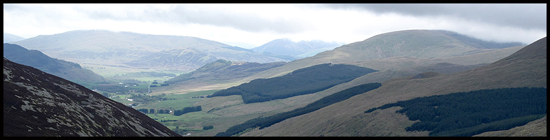
Glen Shee from the slopes of Glas Tulaichean
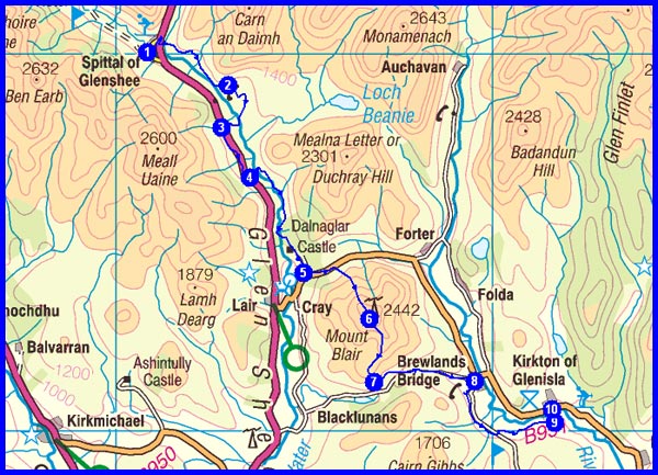
Day 12 - Tuesday 19 May
1 Spittal of Glenshee
2 Westerton of Runavey
3 Dalhenzean
4 Leave the A93
5 B951 road
6 Mount Blair (G)
7 Nether Craig
8 Brewlands Bridge
9 Path junction
10 Glenisla Hotel (250 metres)
Plan
22 km
700 metres ascent
8.9 hours
(1 Graham)
Actual
20.8 km
659 metres ascent
7.4 hours incl 1.3 hour stops
(1 Graham)
Links to blog:
Index
Final Summit
Day 12
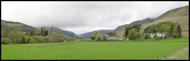
The well-signposted Cateran Trail made the morning's walk very pastoral and straightforward, as we tried to get used to lower climes. The showers were supposed to diminish, but after another doused lunch we headed up our final hill, Mount Blair, in steady rain. But there was a view from the summit, and we found our way to our comfortable hotel at Kirkton of Glenisla via quiet lanes and a very boggy sting in the tail through farmland.
A morning view towards yesterday's route, from the Spittal of Glenshee
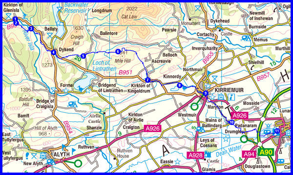
Day 13 - Wednesday 20 May
1 Glenisla Hotel
2 Path junction
3 B951 road
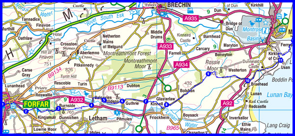
4 Dykend
5 Road junction
6 Gairlaw
7 Kirkton of Kingoldrum
8 By Loch of Kinnordy
9 Kirriemuir
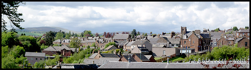
10 Path junction
11 Lochside Caravan Park (campsite in Forfar at 60 metres)
Plan
33 km
460 metres ascent
12.0 hours
Actual
34.6 km
528 metres ascent
8.9 hours incl 1.3 hours stops
Links to blog:
Index
Day 13
Today we found quiet green lanes, with only a little tarmac, for the gentle stroll to Forfar, via the picturesque town of Kirriemuir, with its statue of Peter Pan (JM Barrie was born here). The sounds and sights of the lowland were a delight after previous days of high level moors and mountains (not to denigrate the latter, of course!).
Back to the Fleshpots - Kirriemuir
Day 14 - Thursday 21 May
1 Campsite in Forfar
2 Welton
3 Burnside
4 Road junction
5 Hillside
6 Cotton of Guthrie
7 A933 road
8 Kinnell
9 Nicholl's Loch
10 Braehead of Lunan
11 Usan
12 Scurdie Ness (Finish)
Appendix
5 km road walk to Montrose Camp Site
Plan (including Appendix - AKA 'Sting in Tail')
42 km
440 metres ascent
14.8 hours
Actual
43.1 km
471 metres ascent
9.9 hours incl 1.6 hours stops
Links to blog:
Index
Day 14
An early start saw us getting miles under our belts until we tried a green lanes that was frustratingly blocked. After that we resigned ourselves to mainly tarmac, though we enjoyed a break from that by Nicholl's Loch for our final alfresco lunch.
We took a more direct route to Scurdie Ness than planned and luckily reached the lighthouse at the same time (2.30pm) as Andrew and Eileen Partington, from Bodmin. These were the first Challengers we had seen since the Spittal of Glenshee.
Later, after walking to the Park Hotel, we saw many more.
Party Time!
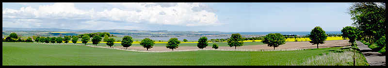
The long straight lane towards Scurdie Ness is on the right, with the Montrose Basin and the sea beyond heralding the end of our stroll
2009 Plan
Total Distance 328 km (205 miles)
Total Ascent 13770 metres
Time 136.7 hours including stops
17 Munros
1 Corbett
3 Grahams
NB Timings are based on 3 kph, plus an hour for each 500 metres of ascent. This is realistic in the mountains but very conservative on the approach to Montrose.
| Actual | 2009 (S + M) | 2008 (S + M) | 2007 (M solo) |
| Total Distance in km (miles) | 333 (208) | 323 (202) | 343 (214) |
| Ascent in metres | 12,400 | 12,544 | 12,942 |
| Hours taken including stops | 118 | 112 | 113 |
| Munros | 13 | 16 | 2 |
| Corbetts | 1 | 3 | 8 |
| Grahams | 3 | 1 | 2 |
| Marilyns not included above | 0 | 0 | 1 |