Home
Bike rides
Sunday 24 July 2005
The Big Macc Ramble
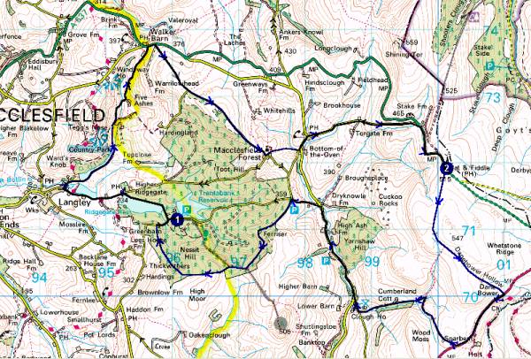
Route
Summary / Report
Blog Reports
1 -> 2 -> 1
Instructions
Start
at the Macclesfield Forest car park/picnic site at Trentabank. (Reached via
Langley from Macclesfield.)
From early 2005 you may find a mobile tea shop on the site, and an overspill
car park just down the road if needed.
Note: There is now a charge for this car park, so it is perhaps better to start from the lay-by beside Ridgegate Reservoir, near the Leather's Smithy.
1 SJ 960 711 - Trentabank Car Park
1->2: 10.71km, 496 metres ascent
Turn left out of the car park at Trentabank then right at the T-junction after
200m at the bottom of the hill. Continue along the road past Ridgegate Reservoir
and turn left at the Leather's Smithy, down into Langley. Hard braking may
be required to take the first right turn in Langley, down Holehouse Lane to
join a track between two small reservoirs.
Continue along the bridleway, turning left at the first opportunity to descend
to and cross a small stream, and dismount for the first (and perhaps only)
time on this ride. After negotiating steps, continue through gates to reach
a metalled lane. Go along here, dipping steeply right to cross a stream (get
in a low gear during the descent!) before rising steeply for 1km to join the
A537 at Walker Barn where there is no longer a pub. (Take a breather!)
Turn right onto the main road for about 100m before turning right again up
a narrow lane, now designated a 'Quiet Lane'. After about 800m the metalled
lane swings left then right to descend, but you carry on upwards beside the
forest on a rough but ridable bridleway, Charity Lane, to the left, with wide views of the
Peak District. After gaining the crest of the hill descend enjoyably on a
track that is very rough at times to the hamlet of Macclesfield Forest. Turn
left then fork right past the small (worth a short visit) chapel down a rough,
steep track (newly laid hard core in 2005 makes this tricky, a short dismount
may be needed) to a T-junction where a left turn is taken. Continue left up
to a road junction opposite the Stanley Arms, where a right turn signals the
start of a long drag up to a junction with the A537 just before the enticing
Peak View tea rooms. Turn left and immediately right here to follow the bridleway up to the Cat and Fiddle Inn. Take a well earned
rest.
2 SK 001 719 - Cat and Fiddle Inn
2->1: 11.41km, 292 metres ascent
Cross the road from the Cat and Fiddle and head across the moor on a recently
rebuilt path across Danebower Hollow. (This used to be a difficult boggy section but can now be negotiated
at speed!) Take care to curb your speed after about 2km on the sharp descent
to the A54. Turn right and dodge the motorbikes for 1km before turning right
at the first opportunity up a gated lane. This soon becomes a superb and increasingly
rockier descent via a sharp left turn (gated) where the route joins Cumberland
Brook. The brook is followed down an increasingly rough track on which newly
deposited rocks in 2005 make one short section a domain of the bold (we dismounted),
and is finally crossed by a ford, soon after which you emerge at the minor
road linking Macclesfield Forest and Wildboarclough.
Turn right for a leisurely 1.5km before taking a left turn steeply up another
'Quiet Lane' to the edge of the forest. Here take a track to the left and
soon enjoy fast sweeping curves through the undulating forest. After a little
more than 1km the track descends over erosion planks. Trying to maintain momentum
and dodge the walkers and their dogs, take a sharp left up the steepest hill
on the route - luckily it's also the shortest. After this the views open out
again as you cross Nessit Hill with the forest below. Continue along the main
path which sweeps enjoyably (if gravelly - take care) through the forest to
reach a junction with a minor road in seemingly no time at all. Turn right
here and take care around the left curve that brings you to a junction where
a right turn leads back up the last 200m to the car park and the welcome mobile
tea room, if it's there. (Or go left to reach the Leather's Smithy.)
1 SJ 960 711 - Trentabank
Car Park
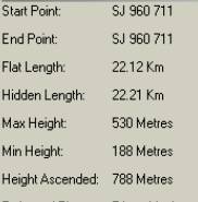
Total distance 22km (14.5 miles), total ascent 788m. This
route can take me anything from just under 2 hours (hard work) to between
2.5 and 3.5 hours. Expect to do it at a leisurely pace in about 3 hours.
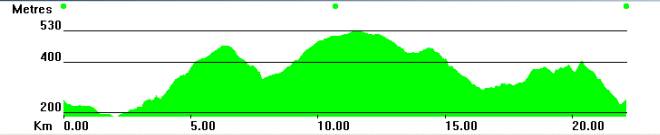
Here are the statistics, and a route
profile
Sue
and I found Andrew waiting for us on a gloomy Sunday morning. After 20 minutes
of faffing etc we zoomed off
down to Langley at 10.10. The conditions were good for cycling and we were
soon toiling up the long hill to the A537,
Andrew walking for part of the climb, but still not far behind. Then a further
climb up the newly designated 'Quiet Lane'
to rejoin the forest. Here Andrew announces his preference for an amble
down to Wildboarclough rather than endure
the long haul up to the Cat and Fiddle, so we leave him to coast along on
his hybrid cycle whilst we enjoy the gentle
climb beside the forest before the occasionally rough descent to the nice
little chapel in Macclesfield Forest hamlet,
reached after an hour.
Some
newly laid rubble spoilt the next short downhill section, and then we were
on the long haul up to the Cat and Fiddle,
in the face of a strong easterly wind. But most of the way it is fairly
sheltered, the traffic and bikers were considerate,
and the 25 minute climb (150 metres) passed thankfully quickly - we did
after all want some exercise today!
The
route description suggests taking a well earned rest here, but at 11.45
am the place was deserted, stuck in a cloud,
and not at all welcoming from the outside, so we eschewed its hidden delights
and headed on away from the desolate
scene, along the lovely smooth path to the A54, the short section along
which was a delight - free wheeling at 35mph
always is. Very enjoyable, if brief, despite the shock of discovering at
speed that my front wheel nut had come loose.
The
track beside Cumberland Brook seemed rougher than usual but was still good
fun (with care) apart from a short
section where a lorry load of rocks had recently been spread roughly over
the track - in the interests of safety we
walked over these.
So
after just over 2 hours we were back on a gently ascending lane after 10.5
miles. A good opportunity for a breather
before the short thrutch up another 'Quiet Lane' to rejoin Andrew at the
edge of the forest. The final half hour up to
1pm was spent swooping along the undulating forest tracks, showing courtesy
to the few people who were out walking.
After a junction where our route goes left, Andrew and I succumbed to the
short hill and walked up it, before enjoying
the fairly smooth descent back down to the road and the final short climb
to the car park, where the mobile cafe
produced large teas and even larger cookies to conclude an excellent outing.
Martin Banfield - July 2005
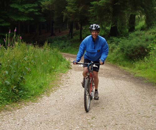
Sue pounds up a hill in Macc Forest near the end of the ride
This route
is from 'The High Peak Trail' - Wheelwright's Mountain Bike Route Guides
- by Tim Woodcock, Future Books 1995.