Home
Weekends
Slaidburn Rentahostel Weekend
16 to 18 March 2007
King's House, Slaidburn, Clitheroe, Lancashire BB7 3ER
0870 770 6034
Click here for details from the web.
And to quote: "17th Century inn has been converted to make a friendly stopover for the Forest of Bowland"
Obviously some will be out to recreate the C17 ambience?!
As you know, we are providing food for the weekend apart from lunches, including nosh for 22 of you on Friday night.
We will put up a note to remind you what you ordered. We'll have some wine but suggest you bring your own drinks if you
want more than a glass or two.
After the meal on Saturday, knowing that some of you like an after-dinner snooze, we may have a slideshow.
One or two of you were going to bring some digital images for that. Please let us know if you are bringing film slides,
otherwise we will assume everything is digital.
See below for a couple of suggested routes.
Here's an extract from the YHA blurb:
"BEDROOM LAYOUT:
32 beds arranged in 1x2, 1x3, 4x4, 1x5 and 1x6 bed rooms. All bed linen is provided.
DINING ROOM/LOUNGE:
The dining room has seating for up to 24 people in one room and 8 in another room. The lounge seats 12 - 15 people.
KITCHEN:
The self-catering kitchen contains 2 domestic cookers with 4 burner hobs, domestic sized fridge and freezer, microwave and a range of kitchen utensils, crockery and cutlery for 32 people. Tea towels are provided.
WASHING FACILITIES:
Washbasins in all rooms, toilet and washbasin off 2 bedded room, 2 showers and 1 toilet on the upper first floor, 2 toilets and 1 shower on first floor and 3 toilets and 1 shower on ground floor. Please bring your own towels.
HEATING:
Full central heating throughout and an open fire in the lounge.
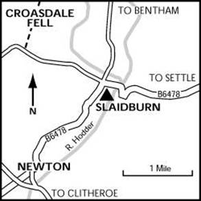
DIRECTIONS:
From Clitheroe take the B6478 to Newton and Settle. From Settle or Skipton take the A65 to Long Preston then the B6478 to Clitheroe. YHA Slaidburn is opposite ‘Hark to Bounty’ Pub.
CAR PARKING:
Space for 6 cars at the rear. Additional parking in the village residents car park 200m away, opposite the tea rooms. Please place a prominent note in the window marked “Resident”.
OTHER INFORMATION:
Post office in Slaidburn.
Food shops - small store in the post office. Supermarkets in Clitheroe.
Banks - most major banks in Clitheroe.
Taxi - A&A Taxis Tel: 443636, Village Taxis Tel: 440244.
Arriving by bus - Tel: 01257 241693.
Arriving by train - Clitheroe (passenger info Preston) Tel: 01772 259439.
Tourist information - 12-14 Market Place, Clitheroe Tel: 442226.
Garage - D Leedham, Dunsop Bridge Tel: 448237.
Mobile phone reception varies, if anyone needs to contact you whilst you are staying here, please advise them to call on the payphone line Tel: 446038In the interests of hygiene, we regret that pets cannot be allowed, although it is possible for special arrangements to be made for Registered Assistance
Please be considerate about parking and to avoid unnecessary disturbance to the neighbours.
Smoking is not permitted in any YHA property."
Routes
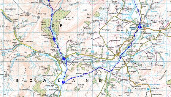
The first is about 28km (17.5 miles) with 800m of ascent. There are short cuts back to Slaidburn. Based on 5kph and 600m ascent adds an hour (approx Naismith) this would take about 7 hours, which seems about right for a good Saturday walk, though it is chosen for its scenic qualities rather than for its attainment of minor summits.
The second route is another scenic one with no summits - about 18km (11 miles) with 400m ascent - about a 4 to 5 hour walk that would be suitable for those wanting to leave for home by mid afternoon on Sunday.
1. Long circuit from Slaidburn
Overview
This walk is adapted from Mike Bexley’s route on http://www.walkingbritain.co.uk/walks/walks/walk_b/2556/
1->2->3->4->5->6->7->8->1
LOCATION DIST
OS Grid Km
1 SD 711 523
Name: YHA Slaidburn
1->2 7.69
Turn left out of the Youth Hostel and L down a path towards Dunnow Hall. Don't cross the bridge - turn R just before it to follow the west bank to the road by Newton.
Cross the bridge and go immediately R along the east bank to reach a lane before Gibbs Farm.
Turn R then R again after the second building. Continue along track for 800m.
Cross Giddy Bridge and head SW up Hodder Bank Fell.
After reaching the watershed head down Fielding Clough to the farm at Burholme.
2 SD 660 485
Name: Burholme
2->3 1.88
Turn R at Burholme and follow the E bank of the river into Dunsop Bridge.
3 SD 660 501
Name: Dunsop Bridge
3->4 1.78
Visit the Telephone Box to discover you are in the centre of The British Isles.
The phone box has a unique number to commemorate this feature.
Cross over the road to pass the petrol station and post office, turning right down the lane prior to the bridge. Continue along the lane (heading north) through fields, behind the cottages then over the River Dunsop.
On reaching the west bank turn right and follow the road passing Bishops House.
4 SD 654 515
Name: Bishops House
4->5 3.43
As you go further into the valley you should see lots of bird life. Look out for the Buzzards high above you
and Oyster Catchers near the river. You will eventually come to a concrete Salmon Ladder, do not cross over the bridge but continue along the road ignoring the footbridge on your right.
The road then climbs to meet a road from coming in from the right.
There is a finger post sign indicating local farms.
Leave the road here and take the bridleway that contours across the western flank of
Middle Knoll looking down on both Brennand Farms. This bridleway terminates at a gate just before a brook.
5 SD 648 546
Name: End of bridleway
5->6 4.45
Go over the stile on the right. The onward path is very wet and at times not visible.
It passes a fenced lake on the left and ends with a very short steep descent to the picturesque
Whitendale Farm (Grid ref 661550).
Turn left through the gate to follow Whitendale River north towards its source.
The footpath leaves the farm track at Grid Reference 657557.
If you miss this path and reach Whitendale Intake, with its dam and water extraction,
you can climb up the bank on the right and rejoin the path. The onward route follows a clear, pole-marked path.
This takes you up the valley eventually leaving the river to climb up to the Roman Road.
6 SD 661 578
Name: Junction with Roman Road
6->7 3.67
Turn right on this old Roman road, which was repaired during Summer 2002 after suffering damage by off-road vehicles, despite signs requesting them not to use it.
Go through the gate and keep to the road continuing down hill for about 3 km.
The views on the left are of Stocks Reservoir and Gisburn Forest.
Eventually reach a minor path to the left, about 500m after crossing Black Brook.
7 SD 689 557
Name: Path junction
7->8 2.64
Take the path L to Croasdale House and follow the E bank of the river to the bridge by Shay Ho. Don't cross.
8 SD 707 544
Name: By Shay House
8->1 2.21
Continue on by the E bank of Croasdale Brook, taking a direct route across meadows beside the brook
before climbing straight ahead over a hill.
During the climb there are some excellent views behind you to the higher fells of the Forest of Bowland.
Just over the summit of the hill the path turns half right to descend to a stile on the Bentham road.
Turn right along the road, back to the Youth Hostel.
1 SD 711 523
Name: YHA Slaidburn
Total trip 27.74
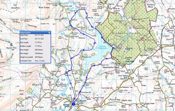
2. Stocks Reservoir from Slaidburn
Overview
This is Lou Johnson’s route on http://www.walkingbritain.co.uk/walks/walks/walk_a/3329/
LOCATION DIST
OS Grid Km
1 SD 711 523
Name: YHA Slaidburn
1->1 17.75
The start is the Youth Hostel or the pay and display car park near the river in Slaidburn (Grid ref. SD714524). Exit the car park and turn right. Walk up to the war memorial in the village centre and turn right onto the road to Bentham. Just after crossing Croasdale Brook turn right onto the path beside the river. The path takes a short cut across meadows to reach the River Hodder at Holmehead Bridge (Grid ref. SD 715531). Cross the bridge and turn left and continue on the track to Hammerton Hall. Passing the Hall on your left bear left at the fork in the tracks (Grid ref. SD719539) and make the steady ascent onto Ten Acre Hill from where you see Stocks Reservoir for the first time.
The path drops down to pass to the left of Black House Farm where a gate allows you to join the main drive. This leads down to a minor road (Grid ref. SD736553). Turn left and pass the chapel on your right. Continue along this road, crossing a causeway over the reservoir, to reach a picnic site where the road turns sharp right (Grid ref. SD732565). Leave the road here and follow the path that shadows the reservoir shore to reach the edge of the plantation (Grid ref. SD725573).
The path crosses Hasgill Beck and soon after becomes a track and leads you up past derelict New House. Stay on this track (not marked on some OS maps) to reach another track at the head of Parks Clough (Grid ref. SD718586). Turn left here and descend to Lock Bridge where you cross the River Hodder. A gentle ascent along this track leads you past the hamlet of Kenibus to join a lane (Grid ref. SD708578). Turn left along this lane from where excellent views are to be had of the surrounding countryside.
Where the lane bends right (grid ref. SD710574) continue straight ahead on a track. This leads you onto the right of way that follows the track bed of the railway that was used during construction of the reservoir (Grid ref. SD713573). There were some signs in this area but they were rather confusing and the use of good map is probably a better to way of route finding. Once the old railway has been reached stay on this for over a mile. Reaching a sign (Grid ref. SD723559), bear right uphill. Keep left of the trees and a ruin, your reach another derelict building.
Keep this on your right and follow the developing path over a small bridge and up to the corner of a wood (Grid ref. SD716559). Continue on the occasionally waymarked route to reach the main drive (Grid ref. SD714556) to Hollins House. Turn right onto this drive to reach a road. Turn left here and walk over Sagar Hill to reach a signed drive to Shay House on your right (Grid ref. SD710546). Follow this drive towards Shay House turning left onto a signed footpath just before reaching Croasdale Brook.
This path takes a direct route across meadows beside the brook before climbing straight ahead over a hill. During the climb there are some excellent views behind you to the higher fells of the Forest of Bowland. Just over the summit of the hill the path turns half right to descend to a stile on the Bentham road. Turn right along the road, left at the war memorial and return through the village to the car park.
1 SD 711 523
Name: YHA Slaidburn
Total trip 17.75
Thats all for now. We hope you find it helpful.
Martin