Home
Evening Walks
Tuesday 24 May 2005
Evening walk from Scorton
Picnic Site
Here are details of the proposed route and
a map.
Call us on 07968 122170 if you are coming but running late.
Regards,
Martin and Sue
Nicky Nook from Scorton Picnic Site
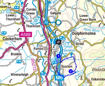
Directions
To get to Scorton Picnic Site (SD 504
504) leave the M6 at junction 33, after Forton services. Turn left down the
A6 (south) and continue for about 1.7 miles to turn left - this is the 5th
left turn after joining the A6.
Pass a church on the left then turn right at a T junction, after which take
the second left road which winds down to the picnic site - on the left shortly
before the road goes over the motorway.
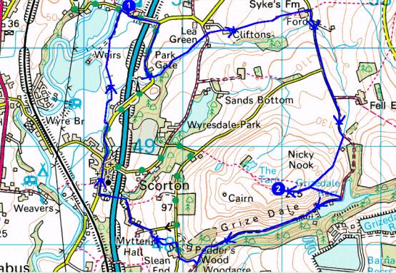
Route
Summary
1- Scorton Picnic
Site >2- Nicky Nook >1- Scorton Picnic
Site
Instructions
1->2 - 5.17km, 196 metres ascent, 1 hr, 22 mins (Naismith)
Go left along the road from the picnic site. Cross over the motorway and take
the road to the right for about 500m. Take a stile to the left just before
a bridge over a small stream and follow this stream over bridges and stiles,
past ducks and geese, until opposite a newish bungalow. Continue to a stile
in the corner of the field and thence a small lane.
Cross the lane and enter another field. Head to the left of a farm (Cliftons)
- go into the farmyard and leave through a gate on the right of the house.
Go uphill by the left hand fence to a stile. Continue in the same direction
over the crest and on to a stile in the left corner of the field. Go on towards
Sykes Farm. Take a permissive path to the left of the farmyard and after crossing
a field join a lane, turn right, cross a ford, and continue south.
Ignore a right turn that leads to Scorton and continue ahead along the rising
lane to Grizedale. After about 500m take the first path off to the right and
ascend Nicky Nook for fine views in all directions, from the Lake District
peaks right down to the Great Orme.
2 Nicky
Nook (SD 519 485)
2->1 - 5.93km, 77 metres ascent, 1 hr, 19 mins (Naismith)
From Nicky Nook retrace slightly to the south of the route up. This leads
to a steep path to the right (ESE) which descends to join a track about half
way around Grizedale Reservoir.
Turn right and continue on down the pretty valley for about 1.5km. At the
bottom of the valley turn right at the footbridge over Grizedale Brook. Follow
a rising path around the edge of a wood for 200m to reach a lane.
Take the first path (or lane if you miss the path) on the left and continue
down, over stiles to the right of the houses, to join a lane which leads under
the motorway to a T junction. Turn right into Scorton for refreshments (perhaps
'Nicky Nook' ale at The Priory).
Continue north for about 400m and take a path to the left some way before
the motorway is crossed. Follow the path and stiles beside the brook near
Scorton Lake (this can be muddy), eventually emerging onto the lane where
the picnic site can be found a few yards to the right.
1 Scorton
Picnic Site (SD 504 504)
Total trip - 11.10km, 273 metres ascent, 2 hrs, 41 mins
The distance is the flat length to the
next Waypoint. Naismith's calculation is based on 5.00 Km/hour and 600 Metres
ascent adds an hour.