Day1 Day2 Day3
Day4 Day5 Day6
Day7
Staveley to Windermere backpack 2 to 8 June 2007
The
planned route is shown below:
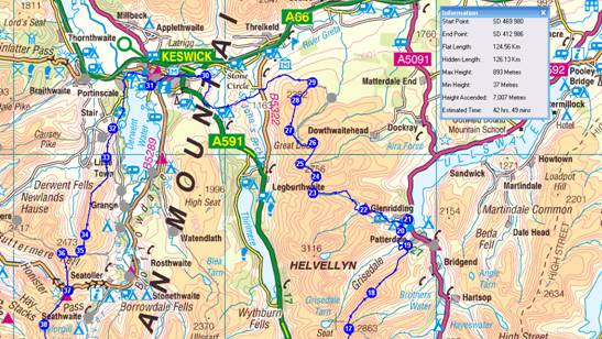
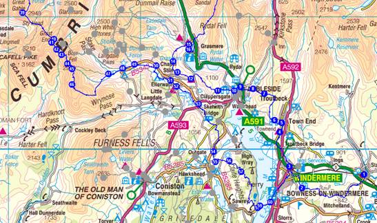
Detailed itinerary
Note the timings shown are based on 4 km/hour and
600 m ascent/hour, compared with
Naismiths formula which is 5 km/hour. Total time excluding stops may slightly
exceed these
estimates.
Top
Saturday 2 June
Take the 13.05 train from Kendal to reach
1 Staveley Station SD 469 980
1->2 6.54 km 248 m ascent 2 hrs, 3 mins
Leave the station and walk down the road and over the A591. Turn R down path that is the Dales Way and continue along the pleasant lanes of the Dales Way, heading generally west towards Windermere. On the outskirts of the town, just before Pinethwaite, leave the Dales Way which heads south.
2 By High Lickbarrow SD 422 970
2->3 2.44 km 17 m ascent 38 mins
Head north nearly all the way to the railway line, turning left to Heathwaite by a small stream. Follow footpaths and back roads to reach Windermere Station (various possible routes for this last km).
3 Windermere Railway Stn SD 412 986
3->4 3.45 km 112 m ascent 1 hr, 3 mins
Cross the A591. Follow footpath through woods below Elleray Bank and High Hay Wood, emerging onto the main A592 road. Go straight ahead on the main road then 1st left down a lane to the A591. Turn R here and cross the bridge in Troutbeck Bridge. Take 1st R up Bridge Lane to reach the Youth Hostel.
4 Windermere
Youth Hostel - 0870 770 6094 (NY 405 012) [B&B and dormitory accommodation]
Total for the day: 12 km, 376m ascent, 3.8 hours walking.
Top
Sunday 3 June
4->5 0.88 km 30 m ascent 16 mins
From the hostel go back to Bridge Lane, turn left, and continue to where the first path goes off to the left.
5 Path Junction NY 407 019
5->6 0.72 km 95 m ascent 20 mins
Turn left and soon reach a lane. Bear left then take the 1st right up a path that soon reaches Robin Lane.
6 Robin Lane NY 401 021
6->7 3.02 km 253 m ascent 1 hr, 11 mins
Turn left up Robin Lane and take the 1st right turn up Hundreds Road. After about 1.5km, just before reaching Nanny Lane, go left, west, on a path rising steeply up to Wansfell Pike.
7 Wansfell Pike NY 393 041
7->8 0.99 km 0 m ascent 15 mins
Continue west, steeply down to Stockghyll Force.
8 Jnc by Stockghyll Force NY 385 045
8->9 1.28 km 2 m ascent 19 mins
Turn left and follow paths on the left bank of Stock Ghyll to reach the centre of Ambleside. Coffee break. Purchase lunch ingredients. Debate whether to order hostel meals for tonight.
9 Ambleside CP NY 375 047
9->10 0.70 km 0 m ascent 11 mins
From Ambleside centre go along the Grasmere road, past Bridge House, and left by the car park SW to reach a bridge to access the lane which has free parking.
10 Lane over bridge NY 371 044
10->11 1.55 km 147 m ascent 38 mins
11 Path jnc on Loughrigg NY 358 044
11->12 2.90 km 224 m ascent 1 hr, 6 mins
Continue NW over Loughrigg Fell, keeping to the high ground, dropping down towards Grasmere and reaching Loughrigg Terrace. Turn left and do not descend to the lake. (That is an optional short-cut.) Instead go left and join the road that leads up to High Close YH.
12 High Close YH NY 338 053
12->13 1.20 km 142 m ascent 32 mins
From the hostel go steeply right up the hillside, keeping high and soon reaching Dow Bank and Spedding Crag.
13 Spedding Crag NY 328 058
13->14 1.12 km 135 m ascent 30 mins
Continue NW then N, high above Grasmere, to reach the summit of Silver How.
14 Silver How NY 324 066
14->15 2.25 km 12 m ascent 35 mins
Go north and gradually curve around to Grasmere, where Butharlyp Howe YH is reached via the Easedale Road, and perhaps via a diversion for cream teas in the fleshpots of the village.
15 Butharlyp Howe YH - 0870 770 5836 (NY 336 079) [B&B and family room]
Total for the day: 17 km, 1038m ascent, 5.9 hours walking.
Top
Monday 4 June
15->16 0.42 km 0 m ascent 6 mins
Stroll into Grasmere for lunch provisions etc, otherwise head directly to the A591.
16 Grasmere Village NY 336 075
16->17 5.97 km 856 m ascent 2 hrs, 55 mins
Go past the church, across the river, then curve around beside the river, leaving it to head N across fields to reach the main A591 road. Turn L and take the 2nd right turn by PH just before the left turn back to Grasmere. Ignore lane to the right and very soon after that turn R up a path that heads steeply and relentlessly upwards to join a broad ridge heading N to Stone Arthur. Continue steeply up NNE to Great Rigg and then on to Fairfield, where the path briefly jinks NW to gain the summit.
17 Fairfield NY 358 117
17->18 2.26 km 169 m ascent 51 mins
Leave Fairfield by its ridge heading N across Cofa Pike and down to Deepdale Hause before rising again to the summit of St Sunday Crag.
18 St Sunday Crag NY 369 134
18->19 2.98 km 18 m ascent 47 mins
Head broadly NNE over Birks to reach a path junction at the foot of Thornhow End, directly S of Glenridding.
19 Path junction NY 386 157
19->20 1.54 km 125 m ascent 36 mins
Turn hard left along the foot of the crags. Take the 1st right to descend further to Thornhow, where right and left turns lead to a path NW crossing Grizedale Beck and straight on up to a path junction where a right turn leads to Lanty's Tarn.
20 Lanty’s Tarn NY 383 163
20->21 0.86 km 1 m ascent 13 mins
Descend to Glenridding Bridge for refreshments. Alternatively turn L at Lanty's Tarn and take the path to Helvellyn Hostel.
21 Glenridding NY 386 169
21->22 2.44 km 147 m ascent 51 mins
From Glenridding take a path/track (any path/track) W to reach Helvellyn Hostel in a state of hydration that may depend on the route taken.
22 Helvellyn YH 0870 770 5862 (NY 366 173) [B&B and room for 5]
Total for the day: 17 km, 1316m ascent, 6.3 hours walking.
Top
Tuesday 5 June
22->23 3.42 km 469 m ascent 1 hr, 38 mins
Head steeply up NW from Helvellyn Hostel past disused mines. After a more gentle section bear left (W) beside Sticks Gill and head up to Sticks Pass.
23 Sticks Pass NY 341 181
23->24 0.87 km 98 m ascent 23 mins
Take the ridge north to Stybarrow Dodd.
24 Stybarrow Dodd NY 343 189
24->25 0.99 km 11 m ascent 16 mins
Continue NW along the broad ridge to reach the summit cairn of Watson's Dodd.
25 Watson’s Dodd NY 335 195
25->26 1.32 km 76 m ascent 27 mins
Take a grassy, possibly marshy, route along the crest of the broad ridge, NNE, to today's high spot, Great Dodd.
26 Great Dodd NY 341 205
26->27 1.54 km 4 m ascent 24 mins
Turn WSW for 250m before curving on a high path to join a path heading NW to the minor summit of Calfhow Pike.
27 Calfhow Pike NY 330 211
27->28 1.50 km 103 m ascent 33 mins
A path leads directly, just E of N, to the summit of Clough Head in 1.5km.
28 Clough Head NY 333 225
28->29 1.15 km 1 m ascent 17 mins
Descend NE to join the Old Coach Road.
29 Old Coach Road NY 341 234
29->30 7.85 km 185 m ascent 2 hrs, 16 mins
Turn left to descend Hausewell Brow and continue around Threlkeld Knotts past various quarries and across footbridges to reach a minor road. Turn left here, then 1st right through fields to cross St John's Beck by a footbridge at Bridge House. Continue in a WSW direction to reach another minor road. Continue past St Johns in the Vale Church and go west to reach the end of a tarmac road leading beyond to Sykes Farm. Carry on here, W, on a path through fields eventually emerging onto the A591. Turn R then immediately R again to head roughly north through more fields to reach the Stone Circle near Goosewell Farm.
30 Stone Circle NY 291 237
30->31 3.12 km 14 m ascent 48 mins
Head W down a lane to Keswick, where the A591 is rejoined briefly then deserted (energy permitting) in favour of the disused railway line below to the left. Continue along this path, going back under the road and crossing the river. Keep left and follow the river to the second footbridge. Cross back to the road, turning R, L, L, R, R, L to reach the Headlands and Lane Rigg House.
31 The Headlands, Keswick NY 264 232 [Lane Rigg Hotel, The Heads, 01768772001]
Total for the day: 22 km, 961m ascent, 7.1 hours walking.
Top
Wednesday 6 June
31->32 4.58 km 116 m ascent 1 hr, 20 mins
Head back to Keswick town centre and take a path L, immediately after crossing the river. Go across fields at the head of Derwent Water to Stormwater Bridge. Go around Derwent Hill into Portinscale. Continue S down the road as far as Derwent Bank where a path bearing left, continuing S, leads along the Cumbria Way through pleasant woods, emerging at a road with parking (the foot of Catbells).
32 Catbells CP NY 247 212
32->33 1.57 km 346 m ascent 58 mins
Head steeply up the ridge to the summit of Catbells.
33 Cat Bells NY 244 198
33->34 4.02 km 340 m ascent 1 hr, 34 mins
Continue S to a col, then rise again, soon turning to the SW onto Maiden Moor. Go S along the broad crest to the summit of High Spy.
34 High Spy NY 234 162
34->35 0.80 km 0 m ascent 12 mins
Following the same southerly route, descend towards Dalehead Tarn for a well earned brew at a path junction at the head of Tongue Gill, or further on at the Tarn.
35 Path Junction NY 231 154
35->36 1.11 km 271 m ascent 44 mins
At the path junction above Tongue Gill, continue S to Dalehead Tarn before turning W and heading up steeply to Dale Head summit. [Alternatively carry on along the path to Honister.]
36 Dale Head NY 223 153
36->37 1.82 km 0 m ascent 27 mins
From Dale Head proceed S to Honister Pass and the nearby Youth Hostel.
37 Honister Hause YH 0870 770 5870 (NY 225 135) [B&B and dormitory accommodation]
Total for the day: 14 km, 1072m ascent, 5.3 hours walking.
Top
Thursday 7 June
37->38 1.97 km 373 m ascent 1 hr, 7 mins
Head SSW from Honister, over Grey Knotts to reach Brandreth.
38 Brandreth NY 214 119
38->39 1.95 km 281 m ascent 57 mins
Go S over Green Gable to Great Gable.
39 Great Gable NY 210 103
39->40 3.32 km 272 m ascent 1 hr, 17 mins
Descend SE to Sty Head. Continue E below Great End the SE to Sprinkling Tarn. The onward path reaches a high point below Allen Crags. [From here a short cut to the Langdale Valley via Angle Tarn and Rossett Gill can be taken, saving an hour.]
40 Turn to Esk Hause NY 234 083
40->41 0.35 km 37 m ascent 9 mins
Go SW to Esk Hause.
41 Esk Hause NY 232 080
41->42 0.67 km 128 m ascent 23 mins
Ascend just S of SE up to the summit of Esk Pike.
42 Esk Pike NY 236 075
42->43 0.63 km 2 m ascent 10 mins
Descend SE to Ore Gap.
43 Ore Gap NY 240 071
43->44 0.99 km 132 m ascent 28 mins
From Ore Gap go initially E, veering to the south up the bouldery slopes of Bowfell.
44 Bowfell NY 244 064
44->45 0.66 km 3 m ascent 10 mins
Descend SE to Three Tarns.
[You can head down The Band from here (NE veering to SE) to speed up your descent to the Langdale Valley.]
45 Three Tarns NY 248 060
45->46 1.41 km 184 m ascent 40 mins
Those still with sufficient energy continue S to the several summits of Crinkle Crags.
46 Crinkle Crags NY 248 048
46->47 4.18 km 86 m ascent 1 hr, 11 mins
Leave Crinkle Crags along its ridge SSE, along a path which after the Bad Step (avoidable but we should manage it) turns ESE towards Great Knott to reach a path descending N into Langdale, just below Red Tarn. [Optional ascent of Pike of Blisco, from here.] Descend to Stool End.
47 Stool End NY 275 056
47->48 1.20 km 0 m ascent 18 mins
Continue to Old Dungeon Ghyll Hotel where refreshments may be taken.
48 ODG Hotel NY 286 061
48->49 1.07 km 12 m ascent 17 mins
A path to the north of the beck leads to the New Hotel for more refreshments/menu recce.
49 NDG Hotel NY 295 064
49->50 1.82 km 28 m ascent 30 mins
A path across fields emerges at the B5343 road near the driveway to Robinson Place.
50 Robinson Place Farm NY 312 063 [01539437214]
Total for the day: 21 km, 1536m ascent, 7.6 hours walking.
Return to NDG for a meal.
Top
Friday 8 June
50->51 2.36 km 19 m ascent 37 mins
From Robinson Place cross the road and take the path south to cross Great Langdale Beck and join the Cumbria Way. Go alongside the beck, past a campsite at New Bridge, and recross the beck to pass through Thrang Farm before reaching the road in Chapel Stile near Wainwrights Inn.
51 Chapel Stile NY 322 051
51->52 0.69 km 15 m ascent 12 mins
Take the footpath on the right bank of the beck, to Elterwater.
52 Elterwater NY 327 047
52->53 2.42 km 30 m ascent 39 mins
The path leads past Elter Water, along the Cumbria Way, to Skelwith Bridge for refreshments.
53 Skelwith Bridge NY 344 034
53->54 4.85 km 174 m ascent 1 hr, 30 mins
Walk down lanes towards Skelwith Fold, turning R before reaching the hamlet. Take 1st left through a field and cross another lane. The path goes past Holmeshead Farm and eventually emerges onto a lane by Brathay Quarries. Go L then 1st R onto a path by the quarries. Continue broadly S through woods to emerge at a road, the B5286, at Dan Becks. Turn R and follow the road into Outgate for more refreshments.
54 Outgate SD 355 998
54->55 0.88 km 21 m ascent 15 mins
Take a path S to reach Loanthwaite Lane.
55 By Crag Wood SD 356 990
55->56 1.25 km 149 m ascent 34 mins
Turn left onto Loanthwaite Lane. At the road junction go L and then immediately R to a footpath leading to this trip's final summit, Latterbarrow.
56 Latterbarrow SD 367 991
56->57 1.64 km 45 m ascent 29 mins
From Latterbarrow follow forest tracks in a SE direction.
57 Jnc N of Claife Heights SD 376 982
57->58 4.65 km 146 m ascent 1 hr, 24 mins
Continue along the high path, with Windermere to the left, roughly SE, aiming for High Blind How's 270m trig point. From here drop to a lower path and contour S through and then above woodland, eventually reaching a track above Far Sawrey. Turn L here, then take the 1st path to the right to descend to a road.
58 Road near ferry SD 388 955
58->59 0.30 km 3 m ascent 5 mins
Walk the short distance to the ferry across Windermere.
59 The Ferry House SD 390 957
59->60 0.88 km 12 m ascent 14 mins
Take the ferry across Windermere.
60 CP at Bowness SD 398 959
60->3 3.30 km 90 m ascent 58 mins
Take a footpath into Bowness and then roads (or a taxi) to Windermere Station and the train back to Kendal.
3 Windermere Station SD 412 986
Total for the day: 23 km, 702m ascent, 7.0 hours walking.
Total trip 124.56 km 7,008 m ascent 42 hrs, 49 mins
Essentials
All participants are recommended to be members of
the Youth Hostels Association or an
affiliated body. YHA membership costs £15.95 and can be obtained by completing
the on-line
form. Alternatively you can pay a supplement of £3 each night.
Top
Kit List
This list
may include items not everyone will need - it's intended as a checklist and
whilst not exhaustive does cover both essentials and luxuries! Obviously, unless
transport of baggage between overnight stops is arranged (the Sherpa
Van Project
provides this service), weight should be kept to a minimum and advice on the
most
effective kit can be provided.
Rucksack
35 to 50 litres plus waterproof liner
Silk liner for use in youth hostels if you dont like their cotton liners
Cagoule / Overtrousers / Fleece / Sunhat
Gloves / Balaclava or woolly hat
Torch (small)
Walking-poles (optional)
Walking Socks (2 pairs) / Underwear / Wicking shirts (2) / Handkerchiefs
Water Bottle(s)
Food for snacks / special teas / other special requirements / Lunchbox
Trainers or sandals for evenings/ Boots or all terrain shoes
Camera / Binoculars / Film / spare batteries for torch and camera / Tripod
Pen / Paper / Book to read / Bog roll
Clock / watch
Glasses / contact lenses (for the poor sighted )/ Glasses case / Cloth Cleaner
Sunglasses / Suntan cream / lip salve
Boot Wax
Toothbrush / Toothpaste / Dental floss / Shampoo / Razor (if prone to hairiness)
Comb / Travel Towel
Lux Flakes or similar to dunk sweaty underwear
Cash / Tickets
Timetables / other papers / Addresses for postcards / This List / Keys
Favourite tapes / CDs / personal stereo)
Additional
items for leader:
Maps
Emergency shelter
Stove / Pan / Mugs / JCloth / Knife / Spoon / butty bags
Matches / needle / thread / tape
Elastoplast/ Aspirin / Diocalm / Savlon / Wipes
Compass / Whistle / First aid kit
Can Opener / penknife