Annapurna Circuit
November 2004

Dhaulagiri (8167m) from the Kali Gandaki valley above Jomsom
Dhaulagiri & Tukuche Peak from Kali Gandaki valley above Jomsom

The Annapurna Circuit is one of the world's classic walks. It offers stunning views of some of the highest mountains in the world and insights into the lives of the Nepali people. Our thanks go to Sanjeev Chhetri (Awesome Travel) who made our experience unforgettable.


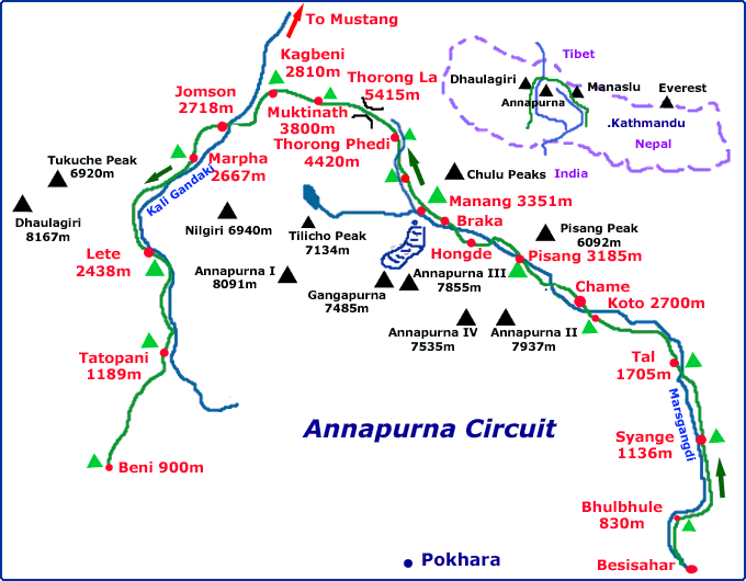
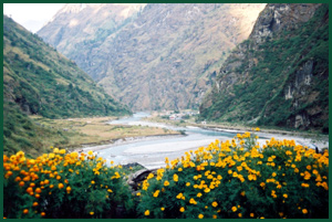
The 125-mile circuit passes through 
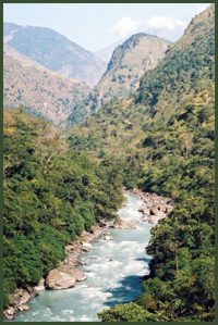
a variety of Himalayan environments, beginning in the lush Marsyangdi 
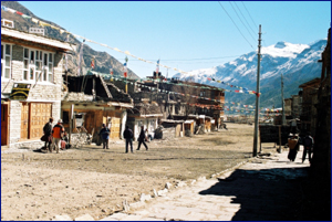
Valley, home of Hindu farming families then entering the dry, arid region 
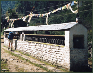
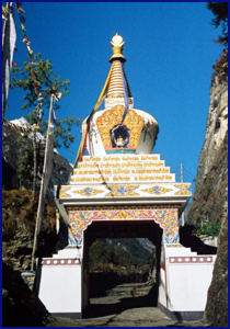
of Manang inhabited by Buddhist Manangis with their Tibetan origins. Higher, 
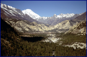
there are spectacular views of mountains such as Annapurna II (7937m), Gangapurna (7485m) and Tilicho Peak (7134m). The crux of the trek is crossing 
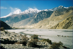
the Thorong La at 5414m where you enter a barren snowy world. There is a long descent to the world's deepest gorge, the 'Kali Gandaki', which splits the Dhaulagiri and Annapurna massifs towering 6000m above.

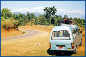
It is possible to do the trek self-supported, staying in the numerous tea-houses along the route, but we chose to do a 'full service' trek. Our guide, sherpas, kitchen staff and porters looked after all our needs, even down to supplying hot water bottles for the cold nights under canvas at higher altitudes!

Map of the Annapurna circuit


Our itinerary
 

Day 1
Day 2
Day 3
Day 4
Day 5
Day 6
Day 7
Day 8
Day 9
Day 10
Day 11
Day 12
Day 13
Day 14
Day 15
Day 16

Drive from Kathmandu to Khudi and walk to Bhulbhule (830m)
Bhulbhule to Syange (1136m)
Syange to Tal (1705m)
Tal to Koto (2700m)
Koto to Pisang (3185m)
Pisang to Manang (3351m)
Acclimatisation in Manang
Manang to Yak Kharka (4090m)
Yak Kharka to Thorong Phedi (4420m)
Thorong Phedi to Muktinath (3800m) via the Thorong La (5414m)
Rest and washing day in Muktinath
Muktinath to Kagbeni (2810m)
Kagbeni to Marpha (2667m)
Marpha to Lete (2438m)
Lete to Tatopani (1189m) to luxuriate in hot springs
Tatopani to Beni (900m)


Day 1: Kathmandu to Bhulbhule
Leaving Kathmandu at 7.30am, we had a 7-8 hour drive ahead of us. Heavy traffic was negotiated passing brick factories to reach the outskirts of the city, then we climbed above the smog to a checkpoint on a pass at 1500m. Views of Manaslu, Ganesh and the Annapurna range opened up in the clear air, whilst the undulating road was surrounded by cultivated terraces, forest and green hills . Frequent hold-ups resulted from colourful but broken down Tata lorries that were unable to cope with the 1000m climb towards Kathmandu! Slogans, such as 'Slow Drive, Long Life' adorned the cabs.

View of himalaya from lunch stop
View of himalayan peaks from our picnic site

Leaving the road for Pokhara at Dumre, we soon stopped for the first of many scenic lunches overlooking himalayan peaks. The road beyond Besi Sahar was too much for our Toyota minibus, so kit was transferred to a bus that negotiated the rutted dirt road, bucking and bouncing, whilst its wheels were sometimes scarily close to the river below. Progress was slow. Reaching the roadhead just before Khudi (792m) at 4.15pm signalled the start of our trek and this was the last we would see of a road for 16 days.
Shouldering day packs we set off for Bhulbhule alongside the Marsyangdi river, which would accompany us much of the way to the Thorong La. The grassy campsite at Bhulbhule was set below the village next to the river, with Manaslu as its backdrop. After a sociable meal, our sirdar, sherpas, cook and kitchen team were introduced and by 9pm we were all ready to retire to our spacious yellow tents.

More photos
Itinerary
Map
Top
Home


Brahmin hill & the Marsyangdi river
Marsyangdi river & 'Brahmin hill'
Day 2: Bhulbhule to Syange (1136m)
Our first full day on trek and 5-6 hours walking to do. The morning routine is a wake-up call at 6am with tea, followed by hot water for washing delivered to the tent door, then breakfast in the dining tent and away around 8am. The trail is busy; porters, trekkers, locals and mule trains plough up and down. In the Marsyangdi valley we are surrounded by lush vegetation, with large spiders clinging to complex webs in the autumn sunshine. Long waterfalls cascade down the valley walls and there is much activity in the rice fields where the ripe crop is being harvested by hand. Threshing is done by buffalo circling around a stake. Birds of prey glide above. There is a steep climb before lunch in Bahundanda ('Brahmin hill', 1311m).
The views from the descent were of hillsides of rice terraces, glowing yellow. We pass our first chortens, ensuring they are on our right. Further undulations and camp is reached at 4pm. The tiny village of Syange is across the river, the valley is steep and a spectacular waterfall is opposite. After dark, fireflies dance around the campsite.
 
More photos


Day 3: Syange to Tal (1705m)
We cross the sturdy suspension bridge to continue on the west side of the river beyond Syange. The steep-sided valley is jungly and it is uphill to the village of Jagat (1314m) , an old custom post in the days of the salt trade with Tibet. The school has a superb wooden four-seater swing. On the way to the next village of Chamje, a lammergeier coasts on the thermals. A huge waterfall plunges into the river, creating rainbows in the spray.

Fertile village of Tal, entrance to Manang district
Village of Tal, entrance to Manang district
We lunch by the river, looking for marijuana, and realising it has died back before the winter. More of the narrow, forested gorge with a zigzag path and rhododendrons until it opens out and we pass through a gateway into a wide valley that signals the start of the Manang district. The village of Tal nestles in the broad valley and our camp is neatly laid out in the garden of the Tibetan Tea House.
More photos
Itinerary
Map
Top
Home


Buddhist prayer wheels
A wall of Buddhist prayer wheels
Day 4: Tal to Koto (2700m)
This 7-8 hour day involved a net height gain of 1000m but was full of interest, particularly in the prominent features of an increasingly Buddhist area. The scenery is becoming more alpine, with forests of pine and rhododendron. This is also the first of a series of cloudless days which make for cold mornings and evenings. We take our daily lemon tea stop on the roof of a restaurant with views of Manaslu up a valley branching off to the east. Just before Bagarchhap Annapurna II (7900m) comes into sight, towering above the valley. We enter the village through a kani, or Buddhist gateway. Bagarchhap suffered a landslide in 1995, killing many locals and several trekkers. A sobering thought as it occurred during November.
In the next village, Danagyu, we find a huge prayer wheel inside a stone hut. It is surprisingly heavy when turned by handles at the bottom. A bell rings as it turns.
Here too, is a wall of prayer wheels that we must walk to the left of. Today also features mani walls, created from ornately carved rocks. From our lunch stop, we look back to Manaslu and Peak 29. The path then undulates high above the river, narrowed in places due to landslips. We catch sight of a group of languar monkeys in the trees across the river and Martin and Sanjeev watch a rat going to and fro from its burrow. Autumn colours become more obvious in the last hour before reaching Koto at 5pm. 
More photos
Itinerary
Map
Top
Home


Day 5: Koto to Pisang (3185m)
We emerge from our tents to a frosty morning outside the 'Superb View Hotel'. A short stroll in the forest brings us to Chame, the administrative centre for Manang district, where our permits are checked at the police checkpost. As the sun warms the air, we remove down jackets. From here, Annapurna II and Annapurna IV can be seen. We leave Chame past an ornate mani wall and stunning kani (entrance gate). The trail switchbacks through pinewoods and where these thin out, apple trees herald the village of Bhratang. The trail then cuts impressively through a steep rock face, built to replace the path the other side, unusable due to landslides. During a 2-hour lunch break, we take in the huge slab of curving rock (Paungda Danda) towering 1500m above us, vegetation barely able to cling to its sides.
After a steep climb then a walk through pinewoods, we descend to an arid area to the left of a tarn that is fairly level. The tibetan-style Upper Pisang clings to the hillside, its plain dwellings blending in to the brown earth. Pisang Peak (6091m) rises behind. Camp is set up beyond Pisang; the sherpas are watering the dusty earth to reduce dust. Buffalo is on the dinner menu!
 
Entrance kani to Chame
Chame's beautiful entrance kani
More photos
Itinerary
Map
Top
Home


Hongde & Tilicho Peak
Airstrip & village of Hongde with Tilicho Peak (7134m) beyond

Day 6: Pisang to Manang (3351m)
The day's walk is short but spectacular. Our campsite was quiet away from the river and dominated by Annapurna II and IV. The temperature has dropped below zero overnight and we wait impatiently for the sun to hit the trail. All the waterfalls are now frozen and a dusting of snow lies on north-facing slopes. The trail rises to a superb viewpoint. Behind is the full glory of Pisang Peak and ahead the village of Hongde with its airstrip lies in a broad pine-lined valley with Tilicho Peak (7134m) in the distance. A twin otter comes in to land and prayer flags flutter noisily in the wind. We drop down a shady, frosty path, then into open scrub to reach Hongde, memorable for its long mani wall in the centre of the main street. Another rooftop stop for lemon tea gives us an eyrie from which to admire Annapurna III (7855m).

A stunning section followed. The valley is wide, with sparse pine and scrub and the rock is dramatically scultured by wind. 'Just' to our left are Annapurna III and IV, albeit 4000m above! We are treated to a himalayan griffon vulture landing close by, then soaring off again into the azure sky.
At 12.30 we reached Braga, famous for its 500-year old monastery that sits above tibetan-style stone houses on the steep hillside. Climbing the steps to the monastery we notice the effects of the altitude at 3505m, breathing heavily! Waiting for the key to be found, we admired the spectacular view, listening to the sound of bells and flapping of prayer flags. The monastery is beautiful, containing coloured hanging flags, cabinets of statues and lined with Thanka paintings. Upstairs a large Buddha resides, guarded by dragons.
After lunch, it was only another 40 minutes walk to Manang where we would spend two nights in order to acclimatise before going on.
During the evening, hot water bottles appeared for the first time!
More photos
Itinerary
Map
Top
Home


Day 7: Acclimatisation in Manang
High street, Manang
High street in Manang 3550m
   

More photos
Itinerary
Map
Top
Home